This product is not available for new orders.
| Services Available | |
|---|---|
| Repair | Yes |
| Free Support | Yes |
Überblick
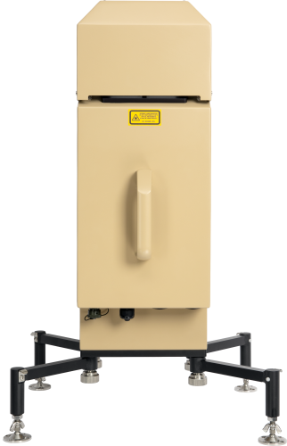
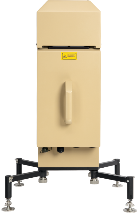
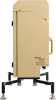
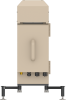
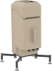
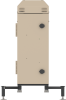
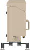
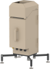
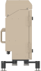
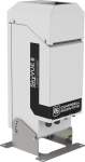
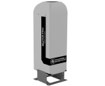
The SkyVue™8M Tactical LIDAR Ceilometer is ideal for quick tactical deployment (for permanent or temporary installation) for military or civilian applications in all climates.
The ceilometer's robust construction requires minimal maintenance and enables continuous use and multiple deployments in the harshest of environments. Designed to be easily portable, the SkyVue 8M has unique quick-deploy stabilizing legs, low weight, and a compact design with a beige finish and two canvas covers to suit all applications.
The SkyVue 8M has many standard features, including a tilting base, a two-axis inclinometer for automatic correction of cloud heights, heaters, blowers, and a sun filter for operation under all conditions—making deployments possible around the world.
The SkyVue 8M has an operating range of 8 km and meets or exceeds all the necessary ICAO, CAA, and WMO requirements and recommendations.
Unique standard features include an easy-to-operate stratocumulus calibration and twin clocks to augment its many continuous diagnostic self-checks and provide assurance of continuous, reliable, and accurate performance.
Lesen Sie mehrFunktionen und Vorteile
- Single-lens design for high signal-to-noise ratio and maximized detector sensitivity, resulting in greater performance at low and high altitudes
- Low weight and small form factor for maximum portability
- Quick-deploy stabilizing legs
- Multiple camouflage options with shroud
- Low power consumption with multiple power options
- Unique continuous comparison of two separate internal quartz clocks to eliminate possibility of clock drift, ensuring measurement confidence
- User-friendly stratocumulus calibration capability and easy test with provided calibrator plate for easy field setup and calibration
Bilder
Zugehörige Produkte
Technische Beschreibung
The SkyVue 8M LIDAR ceilometer measures cloud height and vertical visibility for aviation and meteorological applications. Using LIDAR (LIght Detection And Ranging) technology, the ceilometer transmits fast, low-power laser pulses into the atmosphere and detects backscattered returns from clouds and aerosols above the instrument.
A unique, efficient single-lens design increases optical signal-to-noise ratio and allows for larger optics in a compact package, improving accuracy and measurement performance.
This approach, along with state-of-the-art electronics, provides a powerful and stable platform from which to measure cloud height and vertical visibility to high accuracy. The SkyVue 8M measures the atmosphere with high stability and repeatability, delivering excellent performance in even the harshest of conditions.
The SkyVue 8M provides information on cloud height, sky condition (up to five layers), vertical visibility, and raw backscatter profiles to a range of 8 km.
Kompatibel mit
Please note: The following shows notable compatibility information. It is not a comprehensive list of all compatible products.
Datenlogger
| Product | Compatible | Note |
|---|---|---|
| CR1000 (retired) | ||
| CR1000X (retired) | ||
| CR200X (retired) | ||
| CR216X (retired) | ||
| CR300 (retired) | ||
| CR3000 | ||
| CR310 | ||
| CR350 | ||
| CR5000 (retired) | ||
| CR6 | ||
| CR800 (retired) | ||
| CR850 (retired) | ||
| CR9000X (retired) |
Miscellaneous
| Product | Compatible | Note |
|---|---|---|
| 36215 |
Spezifikationen
| Dimensions | 763 x 360 x 253 mm (30.0 x 14.2 x 10.0 in.) including base and handle |
| Weight | 18 kg (39.7 lb) excluding cables |
Instrument Performance |
|
| Reporting Range | 0 to 8 km (0 to 26,250 ft) |
| Minimum Reporting Resolution | 5 m (16.4 ft) |
| Hard Target Range Accuracy | ±0.25%, ±4.6 m (15.1 ft) |
| Reporting Cycle | 2 to 600s |
| Cloud Layers Reported | Up to four layers (up to five layers in Sky Condition) |
| Sky Condition | Up to five layers with cover in oktas according to WMO requirements for SYNOP and METAR codes as standard |
| Laser Type | InGaAs |
| Laser Wavelength | 912 nm (±5 nm) |
| Military Specification |
|
Electrical Specification |
|
| Power Source |
|
| Interfaces-Maintenance | USB 2.0 (USB 1.1 compatible) |
| Interfaces-Baud Rate | 300 to 115200 bps |
| Interfaces-Data | RS-232 / RS-422* / RS-485* / Ethernet option *The standard wiring of the military output connector does not support RS-422 and RS-485 functionality. Functionality to support RS-485 and RS-422 are available by special order only. |
Environmental Specification |
|
| Temperature Range | -40° to +60°C (-40° to +140°F) |
| Humidity Range | 0 to 100% RH |
| IP Rating | IP66 (NEMA 4X) |
| Maximum Wind Speed | 55 m/s (123 mph) if securely attached to the ground (without camouflage covers) |
Compliance and Testing |
|
| -NOTE- | Further details regarding compliance and testing are available upon request. |
| EMC Compliance | EN 61326-1:2013 |
| Electrical Safety Compliance | EN 61010-1:2010 |
| Laser Safety Compliance | EN 60825-1:2014 |
| Eye Safety Standard | Class 1M |
| Vibration | BS EN 60068-2-6:2008 Test Fc: Vibration (Sinusoidal) |
| Frequency Range | 5 to 150 Hz (exceeds Lloyd's Register test levels) |
Dokumente
Broschüren Produkte
Videos & Tutorials

Downloads
SkyVue Example Programs v.1 (3 KB) 07-11-2019
CRBasic data logger programs for use with CS message 1. One example includes a cyclic redundancy check (CRC).
Please contact support for help with programming to read other message types.
FAQs für
Number of FAQs related to SkyVue 8M: 1
-
The cloud ceiling height relates to the height of the base of the cloud where the sky is overcast or has broken cloud cover.