


Überblick
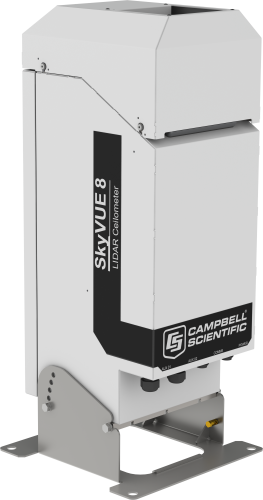
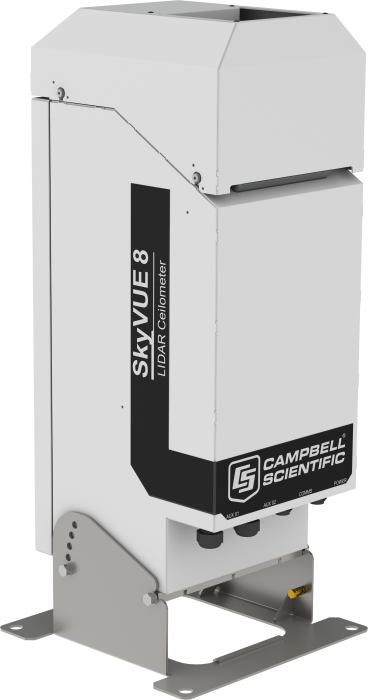
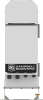
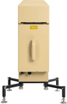
Das SkyVUE™8 ist ein LIDAR-Ceilometer für Flughäfen, Heliports on- und offshore und für meteorologische Anwendungen. Es liefert Daten zur Wolkenhöhe, vertikale Sichtweite und die Rückstreuprofile (Rohdaten). Es erfüllt alle Vorgaben der ICAO, CAA und WMO.
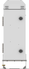
Durch seine robuste Konstruktion erfordert es nur minimale Wartung und ermöglich kontinuierliche Verwendung unter schwierigen Umweltbedingungen. Durch das kompakte Design und das geringe Gewicht von nur 18 kg ist es leicht zu transportieren und aufzubauen.
Das SkyVUE™8 ist einfach zu verwenden. Es hat einen Messbereich bis zu 8 km Höhe. Durch die spezielle Anordnung der Optik und die Signalverarbeitung hat der SkyVUE™8 eine besonders gute Auflösung und Performance.
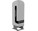
Durch eine eingebaute Heizung und einen Lüfter und einen Sonnenfilter kann er überall auf der Welt eingesetzt werden. Über ein Inklinometer mit 2 Achsen werden die Wolkenhöhen korrigiert.
Standard ist auch die kippbare Basis, eine einfache Stratocumulus-Kalibrierung, langlebige Batterien als Back-up und zwei interne Uhren zur Selbstdiagnose.
Lesen Sie mehrFunktionen und Vorteile
- Spezielles Design der Linse für gutes Verhältnis Signal zu Rauschen und maximale Empfindlichkeit des Detektors
- Gute Leistung zu günstigem Preis
- Geringer Stromverbrauch
- Geneigt auf 24° für bessere Leistung bei Niederschlag und weniger Blenden durch die Sonne.
- Zwei separate interne Quarzuhren um die Genauigkeit zu erhöhen und bessere Messergebnisse zu erhalten.
- Benutzerfreundliche Stratocumulus- Kalibrierung und einfacher Test mit der mitgelieferten Kalibratorplatte, um das Gerät im Feld kalibrieren zu können .
Bilder

Zugehörige Produkte
Technische Beschreibung
The SkyVUE™8 LIDAR ceilometer measures cloud base heights and vertical visibility for meteorological and aviation applications. Using LIDAR (LIght Detection And Ranging) technology, the ceilometer transmits fast, low-power laser pulses (not harmful to eyes) into the atmosphere and detects backscattered returns from clouds and aerosols above the instrument.
A unique, efficient, single-lens design increases optical signal-to-noise ratio and allows for larger optics in a compact package, improving accuracy and measurement performance.
This approach, along with state-of-the-art electronics, provides a powerful and stable platform from which to measure cloud base heights and vertical visibility to high accuracy. The SkyVUE™8 measures the atmosphere with high stability and repeatability, delivering excellent performance in even the harshest of conditions.
The SkyVUE™8 provides information on cloud base heights, sky condition (up to five layers), vertical visibility, and raw backscatter profiles to a range of 8 km.
The unique stratocumulus calibration capability, which allows users to calibrate measurements of scatter coefficients, uses a simple and user-friendly field method, giving complete confidence in the scatter profiles reported and removes the requirement to have the unit sent back for calibration.
Reliable range measurement is further assured by cross-checking two separate internal quartz clocks, eliminating the possibility of unidentified errors due to clock drift.
The SkyVUE™8 can be tilted at various angles up to 24°. Tilting the SkyVUE™ by even a few degrees can be important, as it allows the ceilometer to resist high levels of reflection from large raindrops and frozen particles that can impair vertical-type sensors. The tilt also improves rain run-off on the ceilometer window, resulting in a much higher performance compared with vertical ceilometers.
Tilting to 24° also means that it can be operated anywhere in the world without the sun shining into the lens and resulting in missing data. An internal two-axis inclinometer provides automatic correction of cloud base heights at all angles, ensuring ease of installation and confidence that cloud base heights are automatically corrected throughout the lifetime of the installation.
The SkyVUE™8 complies with ICAO, CAA, and WMO guidance and meets or exceeds all recommendations and specifications. (This includes ICAO 9837, ICAO Annex 3, CAP437, and CAP746.)
Software for data visualization and interpretation
Ceilometer data can be displayed using Campbell’s Viewpoint software or fed directly into existing data systems. The Campbell Viewpoint software will display the output from the ceilometer in a convenient and configurable form, including information on sky condition, mixing layers, scatter profiles, etc. All can be displayed simultaneously or separately with ranges and time scales. For more information on Viewpoint click here.
Spezifikationen
| Dimensions | 737 x 294 x 240 mm (29.0 x 11.6 x 9.5 in.) including tilt base |
| Weight | 18 kg (39.7 lb) |
Instrument Performance |
|
| Reporting Range | 0 to 8 km (0 to 26,250 ft) |
| Minimum Reporting Resolution | 5 m (16.4 ft) |
| Hard Target Range Accuracy | ±0.25%, ±4.6 m (15.1 ft) |
| Reporting Cycle | 2 to 600 s |
| Cloud Layers Reported | Up to four layers |
| Sky Condition | Up to five layers with cover in oktas according to WMO requirements for SYNOP and METAR codes as standard |
| Vertical Visibility | Reported when there is obscuration but no clouds detected |
| Laser Type | InGaAs |
| Laser Wavelength | 912 nm (±5 nm) |
Electrical Specification |
|
| Power Source |
|
| Battery | Internal 12 V 7 Ah battery backup |
| Interfaces |
|
Environmental Specification |
|
| Temperature Range | -40° to +60°C (-40° to +140°F) excluding battery |
| Humidity Range | 0 to 100% RH |
| IP Rating | IP66 (NEMA 4X) |
| Maximum Wind Speed | 55 m/s (123 mph) |
Compliance and Testing |
|
| -NOTE- | Further details regarding compliance and testing are available upon request. |
| EMC Compliance | EN 61326-1:2013 |
| Electrical Safety Compliance | EN 61010-1:2010 |
| Laser Safety Compliance | EN 60825-1:2014 |
| Eye Safety Standard | Class 1M |
| Vibration | BS EN 60068-2-6:2008 Test Fc: Vibration (Sinusoidal) |
| Frequency Range | 5 to 150 Hz (exceeds Lloyd's Register test levels) |
Kompatibel mit
Please note: The following shows notable compatibility information. It is not a comprehensive list of all compatible products.
Datenlogger
| Product | Compatible | Note |
|---|---|---|
| CR1000 (retired) | ||
| CR1000X | ||
| CR300 | ||
| CR3000 | ||
| CR310 | ||
| CR350 | ||
| CR6 | ||
| CR800 (retired) | ||
| CR850 (retired) |
Miscellaneous
| Product | Compatible | Note |
|---|---|---|
| SkyVUE8M Transport Case |
Dokumente
Broschüren Produkte
Videos & Tutorials

Downloads
SkyVue Example Programs v.1 (3 KB) 07-11-2019
CRBasic data logger programs for use with CS message 1. One example includes a cyclic redundancy check (CRC).
Please contact support for help with programming to read other message types.
Campbell Viewpoint v.2.1.0.2 (86 MB) 09-10-2019
Campbell Viewpoint is viewing software designed to accompany the Campbell Scientific optical sensor range, including the CS135 ceilometer, SkyVue PRO, SkyVue 8, SkyVue 8M, CS120A visibility and CS125 present weather sensors. It is free to download (or via email on request) and use for 100 hours, after which you will need to purchase a key to continue using it.
Version 2.1.0.2
Viewpoint version 2.1.0.2 has introduced our new ceilometer sensors to the list of instruments that can be monitored. This includes the SkyVue PRO, SkyVue 8 and SkyVue 8M.
Previous sensors are still available.
Version 2.1.0.2 also includes some minor bug fixes and improvements to the help menu.
SkyVue-8-CS136-OS v.2 (460kb) 11-12-2019
Introduction
Campbell Scientific has introduced a new operating system, OS2 for the SkyVue 8 ceilometer. It is fully backwards compatible. OS2 is available free of charge and can be downloaded from the Campbell Scientific website or supplied by email on request.
Upgrade to OS2 is recommended.
Improvement
OS2 has introduced improvements to optical overlap functions, cloud detection filters and the filter thresholds to reduce false cloud detection at low to medium heights notably up to about 1,000m.
OS2 has increased performance in estimating low level vertical visibility particularly from the ground to 50m.
An option “cloudMode A“ has been added to only report the highest cloud seen during precipitation events. This has been added to further minimise the reporting of rain as low cloud.
OS2 has a new command “application n”, which allows the user to select the recommended, optimum settings for specific applications, including Aviation, Research, Air Quality and Meteorology. In addition, you can specify you own user defaults or select the original default settings for all settings as defined in OS1. OS2 is pre-configured for Aviation use in newly purchased SkyVue 8 sensors or when OS2 is loaded onto a SkyVue 8 running OS1. Individual user settings remain adjustable for further optimisation by the user and for use in other applications.
There is a new option to allow the user to select whether backscatter rolling averages are calculated as mean or median values. The median option is new and is more effective at removing transient signals caused by birds and insects. A new parameter has been added in the BS command to permit users to select either option. Other commands affected include “getuser” and “setuser”.
A “mainsFail” flag has been added to the output messages to indicate failure of mains power whilst operating on the backup battery.
OS2 has introduced a global ID (address) of “99” to permit users to connect to the instrument over a serial connection, if the ID is unknown.
A command “loados” has been added to make it easier to load a full new operating system. The selection of specific individual board operating systems, DSP, TOP and PSU, can still be performed and “loados 4” will continue to function, as in previous OS versions.
OS2 now has a wider range of height offsets to allow greater correction of the height of the sensor than previous OS versions.
Fixes
OS2 includes changes to Sky Condition to improve weighted average cloud heights and prevent the small possibility for arithmetic overflow which may result in a spurious layer being reported.
OS2 also includes improved backscatter filtering to reduce the possibility of noise banding when observed with Viewpoint.
FAQs für
Number of FAQs related to SkyVUE8: 2
-
The cloud ceiling height relates to the height of the base of the cloud where the sky is overcast or has broken cloud cover.
-
Cloud height
Cloud height is commonly used to refer to the height of the cloud base above ground level. (This is what the ceilometer reports.) However, it can also be used to refer to the thickness of a cloud, which is the difference in height between the base and very top of the cloud. It is possible for a ceilometer to estimate the thickness of thinner clouds. Occasionally, when reporting satellite data, it can also be used to refer to the height of the very top of a cloud above ground level.
Cloud layers
At any one time, there may be several separate layers of cloud above a point on the ground. Each of these is a cloud layer, and each is given a cloud base height when it is detected by a ceilometer. The WMO (World Meteorological Organization) has set out rules that govern the minimum vertical separation that is required between layers before reporting more than one layer of cloud.
Cloud base
The cloud base is the lowest part of a cloud that passes overhead. It is typically measured with a ceilometer.
Anwendungsbeispiele
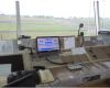
Campbell Scientific’s system integrator, AUDIMOBIL LDA, recently upgraded the airport weather system in the S.......lesen Sie mehr
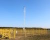
A Campbell Scientific weather station has recently been installed at the Olsztyn-Dajtki airport in Poland,......lesen Sie mehr
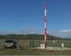
AUDIMOBIL recently installed an Automatic Weather Station in a Portuguese Military Air Base, to support......lesen Sie mehr